Hawkesbury People & Places
Timmins Arm
Creek
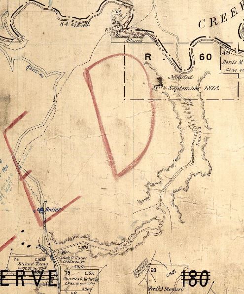
Timmins Arm is the name of a small creek rising in the valley between Jacaranda Road and Weatherboard Ridge Road, Blaxlands Ridge, New South Wales. The creek flows in a north-north-easterly direction until it reaches its confluence with Wheeny Creek. The creek and the track which ran along the watercourse from Comleroy Road to the ford on Wheeny Creek was known by this name as early as 1882 as it was marked on the first edition of the Parish of Merroo, County of Cook map dated February 1882.
Exerpt from the Parish of Merroo, County of Cook map February 1882 showing Timmins Arm and the route along the creek and the crossing at Wheeny Creek
It seems that the route along the creek was named for a drover named Jack Timmins who once moved mobs of cattle with the aid of two dogs from Baerami Station in the Upper Hunter to the meatworks at Riverstone and Homebush via a rough bush track along the bank of the watercourse and crossing Wheeny Creek. An article published in the Windsor and Richmond Gazette on 21 July 1922 lamented the demise of the days when the “the sight of mobs , of ‘fats’ passing through en route to Riverstone and Homebush was one of almost daily occurrence”.
Probably the most interesting of the old brigade was Jack Timmins, who brought his own mobs through from Baerami Station and elsewhere with no other assistance than his two dogs. Jack, like most other men who spend most of their time alone, had a few eccentricities. Whilst the dogs attended to the work with almost human sagacity he unconcernedly followed up on foot playing marbles with himself. He was a ‘cornstalk,’ and many of his relatives reside around Richmond to this day.
Bob Gee, another name well-known in this district, ‘stuck to the road’ until through old age and infirmity he had to be lifted into his saddle, but once there, it is said, his flow of sulphuric superlatives when anything went wrong was as fluent as that of Bennett’s cockatoo. Timmins’ Arm, a track discovered by the first mentioned overlander, across Wheeny mountain is still known by that name, but the Rocky road to Zion is a bowling green in comparison to it.
Source: GNB - Geographical Names Board
A watercourse about 4 kilometres long. It rises about 2 kilometres South by East of Butler Trig. Station and flows generally north-north-east into Wheeny Creek. The name was officially assigned on the 10 October 1975.
Location of Timmins Arm
Topographic Map: MOUNTAIN LAGOON
Categories for Timmins Arm
Related Locations of Timmins Arm
People Related to Timmins Arm
You are welcome to add a comment, provide further information or suggest a correction, relevant to the history of this name.
Please make your comment below. PLEASE NOTE that comments are moderated and only relevant comments will be published
Property Research Service
Have you ever wondered when your house was built or who has owned your property over the years?

